Slavnostní zahájení významného investičního projektu – „Kalové hospodářství ČOV Brno – Modřice“
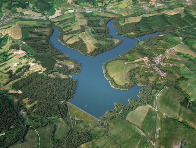
Vlachovice Dam
The project of constructing the Vlachovice Dam consists of a comprehensive set of structures and measures that will together ensure the expected functions of the dam in coexistence with existing populated areas and the local territory and will also ensure appropriate integration of the project into the landscape and natural environment. The current concept does not only concern the hydraulic structure itself but also a set of related investments, changes in the infrastructure, changed use of land and implementation of measures ensuring long-term sustainable use of the newly constructed water resource and stabilization of changed conditions in the area.
Its crucial objective is to construct a functionally integrated set of facilities directly linked to the dam area.
It covers the dam itself including functional civil structures and reconstruction downstream the dam, transfer of water from the Sviborka and Smolinka streams, technological equipment for the dam, transfer of water, residual flow rate energy recovery, set of structures ensuring operation of the dam (especially the operation center, purpose-built roads, utility connections, information center, etc.), a set of modifications in the floodplain, at the limit of backwater, inflow, erosion control measures, belts, stabilization of the reservoir slopes, flow rate metering downstream the reservoir, emergency profiles, measures to incorporate the dam into the landscape, roads, temporary access roads and a set of other related facilities. The project also includes preparatory and demolition work. The construction also includes related relocation of utility lines in the area of the future backwater area.
Parameters:
Top of the dam: 392.00 m a.s.l.,
Dam elevation above the ground is 81.50 m up to 42 m,
Top of the dam length: approx. 560 m2
Total reservoir volume: Vc = 29.12 mil. m3
Protection of areas downstream the reservoir from floods: Q100
Earth-fill dam volume: approx. 1,340,000 m3
Spillway type: Fixed, uncontrolled, single-level
Spillway edge length: 15 m
Work provided by AQUATIS:
Technical- economic study
Investment plan
Utility service network routing survey study
Collection of supporting studies
Design documentation for the joint building permit (DSP)
We would love for you to connect with us
Contact informationAQUATIS is part of the SAFICHEM GROUP. A team of experienced specialists, state-of-the-art working tools and thousands of completed projects are a guarantee for the realization of top projects both at home and abroad.
Navigation
News
Contacts
-
- Address
- Botanická 834/56, 602 00 Brno
-
- Mobile
-
- info@aquatis.cz