Slavnostní zahájení významného investičního projektu – „Kalové hospodářství ČOV Brno – Modřice“
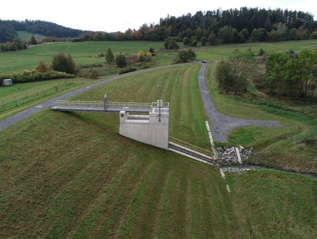
Flood-control reservoir Lichnov III
Investor: Povodí Odry, státní podnik
Locality: The area of interest is located in the Moravian-Silesian Region, in the cadastral area of Lichnov. The dam profile of the designed basin is located west of the municipality of Lichnov, approximately 400 m from the border of a built-up area. It is located on the Tetřevský stream upstream the confluence with the Čižina, which is a tributary of the Opava river.
This locality is part of the Baltic Sea drainage area, the Odra river basin. The Flood-control reservoir is designed to retain floods caused by local heavy rainfall. It concerns reduction of flood-level flows, limiting the sediment movement and protection of the built-up part of the Lichnov municipality against the adverse effects of flood flow rates.
The Flood-control reservoir Lichnov III is homogeneous, of trapezoidal cross-section, horizontal, with a curved axis, 235 m long and 4 m wide at the crest level. Soil needed to construct the dam was extracted from a borrow pit located in the area of future backwater and in its surroundings. The safety and discharge system is a combined structure consisting of an inlet with a gate, safety overspill shaft and a waste passage. Water is conveyed from the basin dam via an open waste trough into the existing channel.
Basic parameters:
Elevation of the dam crest 425.30 m a.s.l.,
Highest water level elevation at PV100 is 424.00 m a.s.l
Dam elevation on the downstream side to the dam toe 9.95 m
Length of the dam 235 m
Width at the dam crest 4m
Volume of earth-fill including drainage and filter 46,300 m 3
Work provided by AQUATIS:
Proposed technical solution for a set of small water reservoirs, investment plan
Proposed technical solution for the Flood-control reservoir Lichnov III, investment plan
Building permit application documentation
Detail design documentation
We would love for you to connect with us
Contact informationAQUATIS is part of the SAFICHEM GROUP. A team of experienced specialists, state-of-the-art working tools and thousands of completed projects are a guarantee for the realization of top projects both at home and abroad.
Navigation
News
Contacts
-
- Address
- Botanická 834/56, 602 00 Brno
-
- Mobile
-
- info@aquatis.cz